What information do the Market Snapshot maps and graphs include?
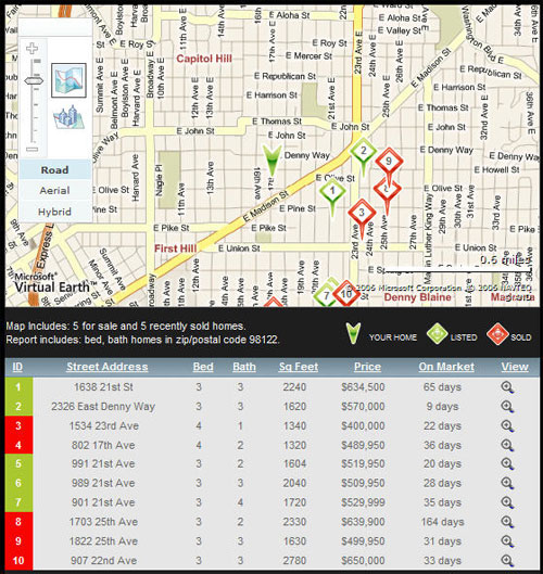
The map area displays your home address (if you are using the Snapshot to calculate the value of your home) or your chosen area of interest (if you are using the snapshot to investigate an area with a mind towards buying) and all the properties found in the area which match the criteria you specified.
Beneath the map, a scrolling grid listing all of the properties used to generate the report’s statistics. The you can choose to show a road map, an aerial (or “satellite”) view, or a hybrid view with both the aerial and the road map. In addition, you can select a “birdseye” view which displays an angled aerial perspective, rather than the “straight down” perspective offered by the conventional aerial view .
Next to the map area is an accordion control that contains graphs and statistics based on the properties displayed on the map. The Market accordion control contains the following views:
- Asking and Sold Prices: Open this part of the control to view a chart which charts the asking and selling prices of the properties that sold within the time span selected from the View Home Prices and Time on Market for drop-down control.
- Asking vs. Selling Price: This part of the control deals exclusively with properties that have actually sold. A bar graph displays the contrast between asking and selling prices for properties sold within the selected time span.
- Time on Market: This view contains information about both currently listed and sold properties. A graph displays high/low days and time on market as linear information, with sold properties marked according to selling price and date within the selected time period.
- Number of Homes: This view breaks down the active listings into newly listed properties and existing listed properties and charts their relationship throughout the time span selected.